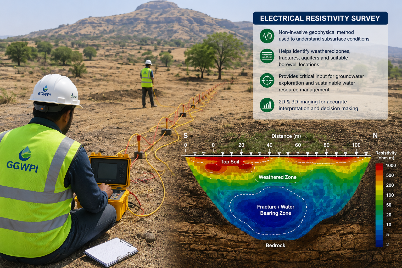
Understanding the Method
What Is Electrical Resistivity?
Electrical resistivity is a physical property that describes how strongly a material opposes the passage of electrical current.
Different soil and rock formations can have different resistivity values. Their response may depend on:
- Mineral composition
- Porosity and permeability
- Water content
- Salinity of groundwater
- Clay content
- Degree of weathering
- Presence of fractures or cavities
Dry, compact and massive rock generally behaves differently from weathered, fractured or water-bearing material. These contrasts allow a geophysicist to develop an interpretation of the subsurface.
How Does an Electrical Resistivity Survey Work?
During the survey, electrical current is introduced into the ground through electrodes. The resulting voltage difference is measured through another pair of electrodes.
The instrument records electrical resistance. Using the electrode geometry and measured resistance, an apparent resistivity value is calculated.
Important distinction
The instrument does not directly detect water. It measures the electrical response of the subsurface. Groundwater potential is interpreted by combining resistivity values with geology, terrain, drainage and local hydrogeological information.
Field Electrode Arrangement
A conventional resistivity survey generally uses four electrodes placed along a survey line.
Two electrodes introduce electrical current into the ground, while the other two measure the resulting voltage difference.
Current Electrodes
Used to inject controlled electrical current into the subsurface.
Potential Electrodes
Used to measure the voltage response created by the current flow.
Progressive Expansion
Increasing electrode spacing allows the survey to investigate progressively greater depths.
The exact arrangement depends on the survey objective, available space, expected depth and geological setting. Vertical Electrical Sounding is commonly used when the objective is to understand changes with depth at a selected location.
How Are the Results Interpreted?
Apparent resistivity values are plotted against electrode spacing. The shape of the resulting curve provides information about changes in subsurface electrical properties with depth.
Interpretation may be carried out using field observations, curve matching, inversion software, geological knowledge and comparison with nearby borewell information.
A typical interpretation may estimate:
- Thickness of soil and overburden
- Depth to weathered formation
- Possible fractured rock zones
- Relative thickness of potential aquifer zones
- Depth to compact or massive bedrock
- Possible clay-dominated or saline formations
What Resistivity Patterns May Indicate Groundwater?
There is no universal resistivity value that always represents groundwater. The same value can indicate different materials in different geological settings.
A potentially favourable groundwater zone may be associated with:
- Weathered rock with adequate thickness
- Fractured or jointed bedrock
- Buried channels or valley-fill deposits
- Coarse alluvial formations
- Contrasts between compact and weathered zones
- Structures that support groundwater storage or movement
Low resistivity does not always mean good groundwater
Very low values may also be caused by clay, saline water, contamination or highly conductive minerals. Geological context is essential.
Important Limitations of the Method
Electrical resistivity is an indirect geophysical method. Its interpretation is not unique, which means more than one subsurface model may explain a similar field response.
Survey quality can also be affected by:
- Insufficient open space for electrode expansion
- Buried pipelines, fences, cables or metallic structures
- Very dry or highly resistive surface soil
- Electrical interference
- Steep terrain
- Poor electrode contact
- Complex or laterally changing geology
A resistivity survey can reduce drilling uncertainty, but it cannot guarantee borewell discharge, water quality or long-term sustainability.
Typical Survey Deliverables
Depending on the agreed scope, a groundwater resistivity-survey report may include:
When Is a Resistivity Survey Recommended?
The method is particularly useful when:
- A new borewell location needs to be selected
- Previous nearby borewells have shown variable results
- The geology is uncertain beneath the site
- Fractured rock or buried channels are being investigated
- Multiple possible drilling points need comparison
- A preliminary groundwater assessment is required
For larger sites, multiple survey points are generally more informative than relying on a single sounding. The number and spacing of points should reflect the site area, geology, access and project objective.
Key Takeaway
Resistivity Helps Reduce—Not Eliminate—Drilling Risk
Electrical resistivity surveying is a valuable tool for identifying subsurface contrasts that may relate to weathering, fractures and potential groundwater storage.
Its value is greatest when measurements are collected carefully and interpreted together with geology, terrain, drainage, borewell records and field observations.