Understanding the Method
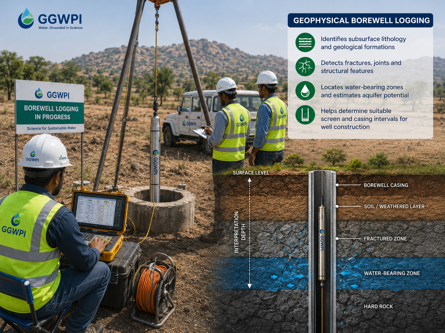
What Is Geophysical Borewell Logging?
Geophysical borewell logging is the measurement of physical properties along the depth of a borewell using specialised probes lowered into the hole.
As the probe moves through the borewell, the logging system records measurements at closely spaced depth intervals. The result is a continuous vertical profile rather than information from only a few selected depths.
Depending on the instrument and project objective, the measurements may respond to:
- Electrical properties of formations
- Natural radioactivity
- Fluid characteristics
- Borewell diameter
- Temperature
- Natural electrical potential
- Acoustic or structural properties
How Does Borewell Logging Work?
A logging probe is connected to a calibrated cable and lowered into the borewell. The cable allows the operator to determine the depth of the probe while transmitting measurements to the surface equipment.
Logging is commonly recorded while the probe is moved upward at a controlled speed. The measurements are displayed as curves against depth.
Probe Lowering
The selected probe is lowered safely to the required logging depth.
Controlled Recording
Measurements are recorded continuously while the probe travels through the borewell.
Depth Correlation
Changes in the recorded curves are correlated with depth, geology and drilling observations.
Logging measures properties, not direct yield
A log may help identify promising water-bearing intervals, but it does not directly guarantee the final discharge or long-term sustainability of a borewell.
Common Borewell Logging Parameters
The logging programme should be selected according to the borewell condition, casing status, diameter, fluid level and project objective.
Not every borewell requires or permits every logging parameter. For example, casing and borewell conditions can restrict the usefulness of certain measurements.
How Are Borewell Logs Interpreted?
Individual curves are first reviewed for changes, peaks, shifts and repeated patterns. The strongest interpretation generally comes from comparing multiple logs rather than relying on a single parameter.
Interpretation may also use:
- Driller’s lithological log
- Rock and soil cuttings
- Depths of reported water strikes
- Borewell construction records
- Casing and screen information
- Pumping or yield observations
- Nearby geological and borewell information
A change visible on one log may have several possible causes. Correlation between multiple measurements helps reduce ambiguity.
How Can Logging Help Identify Aquifer Zones?
A potential aquifer interval may be associated with fractured rock, weathered formations, permeable sediments or other zones capable of transmitting and storing groundwater.
Logging may help recognise these zones through a combination of:
- Changes in electrical resistivity
- Natural gamma contrasts
- Temperature anomalies
- Fluid-conductivity changes
- Borewell-diameter enlargement
- Correlation with observed fractures or water strikes
A curve anomaly is not automatically an aquifer
The same response may be produced by clay, mineralisation, casing effects, borewell-fluid changes or instrument conditions. Interpretation must consider the complete borewell context.
How Logging Supports Casing and Screen Decisions
In suitable borewells, interpreted logs can support decisions relating to the placement of screens or slotted casing.
The objective is to identify intervals that are more likely to contribute groundwater while avoiding unstable, clay-rich or otherwise unsuitable zones.
A screen recommendation should consider:
- Interpreted aquifer intervals
- Formation stability
- Borewell diameter
- Expected pumping requirement
- Observed sand or silt entry
- Drilling and construction method
- Applicable departmental or engineering specifications
Geophysical logging provides technical support for borewell design, but the final construction decision must also consider drilling conditions and engineering requirements.
Important Limitations and Field Requirements
Successful logging depends on safe access to the borewell and suitable borewell conditions.
Common limitations include:
- Obstruction within the borewell
- Insufficient borewell diameter
- Collapsed or unstable sections
- Existing casing that affects certain measurements
- Inadequate water level for fluid-dependent logs
- Risk of probe entrapment
- Incorrect or uncertain borewell depth
- Electrical noise or instrument limitations
The logging team should be informed in advance about borewell depth, diameter, casing, pump installation, known obstructions and current construction status.
Typical Borewell Logging Deliverables
Depending on the agreed scope, a logging report may include:
Key Takeaway
Borewell Logging Converts Depth into Usable Information
Geophysical logging provides a continuous record of selected physical properties along a borewell. It can improve the understanding of geological changes, fractures and potential water-bearing intervals.
Its greatest value comes from integrating the logs with drilling observations, cuttings, borewell construction details and hydrogeological knowledge.